Experts will have to resolve many questions about the storm's passage through an area that was considered low-risk
EFE
The National Institute of Meteorology (INM) believes that there are still unknowns to be resolved regarding how a disturbance in the north of the tropical Atlantic could hit the Canary Islands almost directly, and calls for detailed studies to explain the factors that led the "Delta" storm to subtropical latitudes.
In a study on the tropical storm "Delta" in the Canary Islands, published online by the General Secretariat for the Prevention of Pollution and Climate Change, it is indicated that meteorologists must reveal how this atmospheric disturbance could evolve towards higher latitudes without weakening during its displacement.
Another unknown is how the storm subsequently dragged itself "along the southern edge of a polar trough to hit the Canary Islands almost directly" and then headed, very weakened, to North Africa.
Normally, according to the study, the storm would have been dragged west by the weak tropical flows of middle and high levels "or die in the same area where it originated".
More unknowns
A concatenation of events, some of them "difficult to assess at the present time", caused the "Delta" to evolve towards higher latitudes, where the polar circulation had retreated and, subsequently, it was captured by the westerly flow associated with a trough located in the vicinity of the Iberian Peninsula.
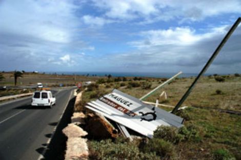
The irruption of the tropical storm in the Canary Islands has been a "very special" event from a meteorological and phenomenological point of view and caused a great deal of damage due to the very strong generalized wind, although the most active area of precipitation was located far from the islands.
Gusts of 118 kilometers
The winds on land became very intense and on occasions exceeded speeds that can be described as hurricane-force, exceeding 118 kilometers per hour in almost all the islands, the INM points out.
It also recalls that the tropical cyclone season in the Atlantic basin has been more active than normal in the number of storms and major hurricanes, and believes it is necessary to carry out more detailed studies with a greater number of data and have numerical model simulations that take into account the complex atmosphere-ocean interactions.
These studies would also allow us to better understand the interactions between tropical disturbances and mid-latitudes, which seems to have played a prominent role in the evolution of the "Delta" storm and in the development and evolution of Hurricane "Vince" in the Iberian Peninsula in October 2005.
The INM specifies that it has followed "this singular disturbance" from the first moment, especially in the previous days when the predicted trajectories of the tropical storm pointed "with a certain degree of uncertainty" towards the Canary Islands.
The surveillance was accentuated when the predictions pointed towards the islands as an area that could potentially be affected, especially by very intense winds, although the most active areas with convective precipitation passed far from the archipelago.
USA, the first warning
According to the study, the storm formed in the subtropical Atlantic at 25 degrees north and 40 west, and the US National Hurricane Center issued the first warning on November 23, although the initial displacement was erratic and slow.
Subsequently, the disturbance was moving north to take a direction that would take it to the vicinity of the islands.
According to data captured by the Izaña Observatory (Tenerife), the wind was "extremely intense" with gusts of about 248 kilometers per hour - later exceeded "widely" on several occasions - and with relatively warm associated temperatures and high humidity, as corresponds to a tropical mass, "but at 2,367 meters above sea level".
The harshness of the storm
The effects of "Delta" were felt mainly in wind and to a lesser extent in rain and according to satellite images the largest foci were placed north of the islands, and it was after 6:00 p.m. when the most intense gusts were recorded.
According to data captured at the Canary Islands airports, the maximum wind gust occurred at La Palma aerodrome, with 152 kilometers per hour; 147 at Los Rodeos; 136 in El Hierro; 134 in Tenerife South; 120 in La Gomera; 102 in Gran Canaria; 100 in Fuerteventura and 91 in Lanzarote.


