
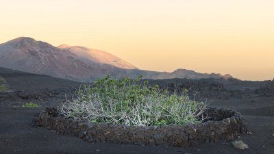
There was a time when the Fire Mountains were not yet one of Lanzarote's great icons. They were the memory of a catastrophe that had occurred more than two centuries earlier, a harsh territory, difficult to traverse and apparently useless for agriculture. The eruptions of 1730 to 1736 had buried villages, farmlands, and roads under lava and lapilli and had forever transformed a large part of the island's center and southwest. What for the generations who had lived through the tragedy had represented destruction, began to be contemplated decades later with different eyes.
The change did not happen overnight. And September 17, 1974, the date on which the decree creating the National Park was published in the BOE, was actually the culmination of a process that had begun in Lanzarote four years earlier. The official document allows us to pinpoint the history: the decree had been approved by the Government on August 9, 1974, and would legally come into force on October 7. But it was on that September 17 that the decision was made public in the Official State Gazette and Timanfaya was formally incorporated into the Spanish network of National Parks.
The story had begun in the Cabildo of Lanzarote. On October 14, 1970, the Plenary of the island Corporation unanimously approved a motion presented by its president, José Ramírez Cerdá, to initiate the process to request that the Fire Mountains, in the municipal districts of Tinajo and Yaiza, be recognized as the Timanfaya Volcanic National Park. The document preserved by Memoria de Lanzarote makes that session a fundamental piece for understanding what happened next: the initiative to protect the volcanoes came from the island itself.
Ramírez was not alone. César Manrique and Jesús Soto, two men who would prove decisive in transforming the perception of the Lanzarote landscape, participated in that process. Later, José Miguel González, from ICONA, joined, while the forestry engineer Juan Nogales prepared the preliminary study that would serve as the basis for moving towards the declaration. In March 1974, the public information period began, and the island's authorities and associations were consulted on the proposal. The result was favorable to the declaration.
There is a story that has become associated with the birth of this idea and that helps to explain the extent to which the view of Lanzarote was changing: that of a postcard of a volcanic landscape from New Mexico that allegedly came into the hands of José Ramírez and made him contemplate the Fire Mountains in a different way. The image, according to this version, allowed for a simple but powerful comparison to be made: what was considered worthy of protection and admiration elsewhere in the world could be precisely what Lanzarote had right before its eyes. The story is revealing, although it is worth distinguishing it from the documentarily proven fact: the minutes of the Cabildo of 1970 accredit the institutional initiative to request the declaration, while the episode of the postcard belongs to the subsequent reconstruction of that process.
The transformation of Timanfaya also had a paradox that may seem surprising today. When it was decided to protect the Fire Mountains, the landscape was already being prepared to receive visitors. Lanzarote had begun to discover that its volcanoes, far from being solely a wound of the past, could become one of its great cultural and tourist resources. José Ramírez, César Manrique, and Jesús Soto participated in a strategy that aimed to showcase the territory without turning it into a conventional landscape of tourist exploitation. The creation of access roads, routes, and facilities allowed visitors to approach a space that had previously been difficult to traverse.
The decree of 1974 would expressly recognize this reality. Its preamble explained that the peculiar beauty of Timanfaya already attracted those who arrived in Lanzarote. Therefore, it was not a territory completely unknown to tourism that was being protected, but a landscape that had already begun to arouse interest and that precisely for that reason needed protection. The stated objective was to preserve the place as it had been preserved until then and to condition it so that it could be contemplated by present and future generations.
The formulation is especially interesting if observed from the present. The State was not simply proposing to close the territory to visitors. Protection was also linked to the possibility of knowing it. The decree itself established that the Park Board should promote the necessary access to visit the areas of greatest interest and defend the particularities of the place so that they would be respected by those who came to contemplate it. Conservation and visitation thus appeared united from the legal birth of Timanfaya.
And there was more. The facilities and services that the Cabildo of Lanzarote had created before the declaration would continue under the administration of the island Corporation. It was even contemplated that ICONA could delegate to the Cabildo the administration of the facilities and services that would be created later. The birth of the National Park did not, therefore, mean erasing the tourist experience developed by Lanzarote, but rather incorporating it into a new framework of protection.
The legal text is also revealing due to the language it used. The decree spoke of a landscape of "singular beauty," formed by volcanic cones, lava flows of different shades, and blankets of lapilli, and even observed the scarce patches of lichens that had begun to colonize those soils. That description contained an idea that today seems evident, but which at the time represented a profound change: the landscape of Timanfaya had its own value and should be preserved for what it was, not for its capacity to produce immediate wealth.
The paradox is that the territory that seemed most dead was beginning to show precisely the opposite. On the recent lavas, life had slowly begun to return. The lichens were one of the first visible signs of a process of biological colonization that continues to be part of the uniqueness of this landscape. Timanfaya was not a desert without history or life: it was a territory in transformation, a natural laboratory born from one of the greatest volcanic crises experienced by Lanzarote.
The eruptions that began in 1730 and lasted for six years transformed approximately 174 square kilometers of the island. Timanfaya preserves an essential part of that volcanic territory and concentrates an extraordinary succession of cones, craters, lava flows, and lapilli fields. The park, which was legally established in 1974, therefore protects a fundamental part of the physical memory of that catastrophe that changed Lanzarote forever.
But September 17, 1974, was not just an environmental date. It was also a decisive moment in the construction of a new island identity. Lanzarote was beginning to understand that its landscape could be its main heritage. While other Spanish tourist areas transformed their coasts through accelerated urbanization, the island tried another path: to turn its volcanoes, its architecture, its villages, and its natural spaces into part of the same territorial image.
César Manrique would be fundamental in this transformation, although it would be unfair to reduce the entire process to a single figure. The declaration of Timanfaya was the result of a sum of wills: a political initiative by the Cabildo, the intervention of Manrique and Soto, the technical work of those responsible for ICONA, the study by engineer Juan Nogales, the participation of the island's authorities and associations, and finally, the State's decision. The official history of the National Park itself identifies this path and points out that the Cabildo defended its existing rights over the exploitation of tourist services during the process, rights that were respected.
What happened in 1974 becomes even more important when observing what happened afterward. The initial protection was not the final point. In 1981, Law 6/1981 reclassified the Timanfaya National Park and consolidated its legal framework. From then on, protection would reach a broader dimension, incorporating the geological, biological, archaeological, cultural, educational, and scientific values of the space. The Ministry for Ecological Transition considers both dates as fundamental milestones: the 1974 creation decree and the 1981 reclassification law.
Between one date and another, something deeper than a legislative modification occurred. An idea of Lanzarote was consolidated that is still part of its identity today: that the landscape is not the backdrop left after construction, but one of the island's main assets.
That is why it is significant to return to the text of that 1974 decree. The regulation ordered the conservation of the land and landscape in a state similar to what they were then and subjected any work or activity that could cause physical or landscape alteration to authorization. At a time when environmental language did not yet have the current presence, that decision already introduced a warning that retains all its validity: what attracted visitors could disappear if it was intervened upon without limits.
Half a century later, Timanfaya continues to pose the same question with even greater intensity. How can an extraordinary landscape be taught without consuming it? How can tourism approach a protected territory without ending up transforming it? Where is the balance between enjoying natural heritage and preserving precisely what makes it possible to enjoy it?
The answer that Lanzarote began to experiment with in the seventies was unique. It did not consist of hiding the volcanoes, but of making their contemplation possible within certain rules. It was not about turning Timanfaya into a theme park, but about making the landscape itself the experience. The architecture, the routes, and the observation points had to accompany the territory without competing with it.
Perhaps therein lies the true significance of that September 17th. Timanfaya did not become a National Park because someone suddenly discovered that Lanzarote had volcanoes. The volcanoes had been there long before the island we know existed. What changed was the human gaze upon them.
For centuries they were a threat. Then they were a difficulty. Later they became a curiosity for visitors. And finally, they became heritage.
On September 17, 1974, Lanzarote managed to have that last gaze written in the Official State Gazette. The island did not only protect a set of volcanoes: it protected a part of its memory and, in doing so, decided that the landscape born of destruction should also become a heritage for the future.
Sources: Official State Gazette, Decree 2615/1974, of August 9, creating the Timanfaya National Park; Government of the Canary Islands, history of the Timanfaya National Park; Ministry for the Ecological Transition and the Demographic Challenge, Network of National Parks; Lanzarote Memory, historical documentation of the Cabildo de Lanzarote and minutes of the Plenary Session of October 14, 1970.


Add La Voz de Lanzarote as a preferred Google source.
Stay informed with the latest current news.