
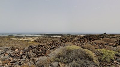
Caletón Blanco is one of the most recognizable images in northern Lanzarote. The white sand, volcanic lava flows, and pools of transparent water have turned this corner of Órzola, in the municipality of Haría, into a place of great attraction for residents and visitors. However, beneath this tourist facade lies a less visible transformation: a protected plant has lost more than 92% of the surface area it occupied in one of the studied areas.
The data appears in a conservation report prepared for the Government of the Canary Islands in July 2025. The affected species is the marsh samphire (Sarcocornia perennis), included in the special protection category of the Canary Catalogue of Protected Species. Its decline makes the conservation status of this enclave a matter that transcends its landscape value.
The magnitude of the loss forces us to look beyond the image of a beach that continues to attract those seeking one of Lanzarote's most unique landscapes. The conservation of natural heritage requires knowing what is happening on the ground, identifying the pressures affecting species, and verifying whether protection measures are yielding results.
More than 8,000 square meters of decline
The report's figures allow us to gauge the change. In 2002, the marsh samphire occupied 8,767.75 square meters in the Caletón Blanco area. In 2025, the registered area was 642.18 square meters. The difference, 8,125.57 square meters, is equivalent to a reduction of 92.68%.
The percentage refers to the area occupied by the species' stands, not the number of individual plants. It does not, therefore, mean that exactly that percentage of specimens has disappeared, but it does indicate an extraordinary contraction of the space where this protected vegetation develops.
The document identifies specific pressures on the habitat. During fieldwork, bathers were observed practically on top of the specimens, uprooted and dead plants, marine litter, and hydrocarbon residues. Trampling, soil compaction, and habitat fragmentation are also among the factors hindering the conservation of the species.
To these impacts are added threats such as coastal erosion and sea-level rise. The authors also warn of the pressure from recreational and tourist activities in the coves and rock pools of Órzola, which has possibly increased with the influx of visitors and residents.
The study does not attribute all the loss to a single cause, nor does it allow for exclusive blame on tourism. It does describe observed impacts on the ground and points out threats that must be taken into account when designing protection measures. This distinction is fundamental to avoid conclusions that go beyond what the research demonstrates.
Is legal protection sufficient to conserve the species?
The magnitude of the retreat raises specific questions for the competent administrations. Have the most sensitive areas been delimited to prevent trampling? Have measures been taken to regulate access to the sectors where the plant survives? Is there monitoring that allows its evolution to be known after the 2025 evaluation?
The report from the Government of the Canary Islands constitutes a scientific reference for assessing the situation, but it does not, on its own, allow us to determine what specific actions have been carried out since its publication or what their results have been. The documentation consulted also does not allow us to confirm whether subsequent monitoring of the Caletón Blanco nucleus has been carried out.
Therefore, it is necessary to know what conservation measures have been adopted, which bodies are responsible for their implementation, and whether there are evaluations that allow their effectiveness to be verified. The situation requires verifiable information, both on the actions taken and on the results obtained.
This is not to presume that nothing has been done, but rather to know what actions have been carried out, with what objectives, and with what results. The inclusion of a species in a protection catalog establishes a legal framework, but its effective conservation requires interventions adapted to the identified threats and mechanisms to evaluate their effectiveness.
The question, therefore, is not only what protection the regulations recognize, but how that protection translates into concrete measures on the ground. When scientific data reflect such a pronounced reduction in the area occupied by a species, knowing the administrative response becomes a matter of public interest.
Images of a Changing Coastline
The history of Caletón Blanco can also be reconstructed through visual documents. Memoria de Lanzarote preserves a Super 8 home movie made around 1982 by Ángel Corujo. The recording begins in Caletón Blanco and continues through Órzola, where structures of old salt flats appear, before touring other locations in the municipality of Haría and the Chinijo Archipelago.
The film offers a testimony of the landscape from more than four decades ago. It does not allow us to establish how many people visited the beach then, nor to determine when its tourist popularization began, but it constitutes a reference for studying the evolution of the environment.
To this source are added the historical orthophotos from IDECanarias, including those corresponding to 1982 and 1992. Their comparison with flights from other years can help identify transformations in access, constructions, and land occupation. To date specific changes, it is necessary to examine equivalent sectors and apply appropriate cartographic criteria.
These images provide historical context, although they do not replace the scientific studies necessary to evaluate vegetation evolution. Landscape reconstruction and species monitoring are complementary, but distinct, lines of research.
The value of these sources lies in their ability to document how the environment has changed over time. However, to establish a relationship between landscape transformation and vegetation loss, it is necessary to have specific studies that compare the same areas and use appropriate analysis procedures.
The Coastline, Between Management and Environmental Risks
The administrative dimension is also part of the history of this coast. On August 30, 2023, the delimitation of the maritime-terrestrial public domain of a stretch of approximately 2,224 meters between El Embarcadero and Caletón beach, in the municipality of Haría, was approved. The resolution was published in the Official State Gazette on September 25 of that year.
The file brings together geomorphological, historical, photographic, and cartographic documentation to legally define this stretch. Its existence allows us to understand the complexity of coastal management, but it does not, in itself, prove environmental damage nor does it replace the specific actions that a protected species may require.
In September 2025, the grounding and subsequent fire of a tuna boat in Órzola caused spills and the temporary closure of Caletón Blanco and other nearby areas. The Haría City Council reported on the preventive measures adopted and, subsequently, on the continuation of the work to remove the vessel and clean up, while the closure of the affected areas was maintained until the absence of contamination risk was confirmed.
There is no sufficient basis to relate that episode to the reduction in vegetation cover recorded between 2002 and 2025, nor to affirm that it caused permanent damage to the beach. It is a different episode that illustrates the coastline's exposure to environmental risks and the importance of having prevention and response mechanisms.
The management of these spaces therefore requires differentiating documented problems from those whose causal relationship has not been demonstrated. The protection of the coast, the prevention of spills, and the conservation of plant species require coordinated actions, but each intervention must be supported by the corresponding scientific and administrative information.
Conserve Beyond the Postcard
The north of Lanzarote maintains a long relationship with the sea and its resources. The Salinas del Río, also known as Salinas de Bajo el Risco or Salinas de Gusa, are part of that historical and economic heritage. Although they are located outside Caletón Blanco, their trajectory helps to contextualize the relationship between human activities and the coastal environment before the current tourist popularity.
Determining when Caletón Blanco began to consolidate as a tourist destination requires specific research in historical press, travel guides, promotional brochures, and municipal archives. The sources gathered allow us to document the existence of images of the enclave around 1982 and its current tourist recognition, but not to set an exact date for that change.
The central figure is delimited: in the studied core, the area occupied by the marsh salt flat went from 8,767.75 square meters in 2002 to 642.18 in 2025. A reduction of 92.68% that forces us to ask what actions can guarantee the survival of the vegetation that still remains.
Who protects Caletón Blanco? The answer cannot be limited to the existence of a legal protection figure. It must be specified in verifiable measures, identifiable responsible parties, scientific monitoring, and accessible results. When a protected species loses more than nine-tenths of the surface area it occupied in a studied core, evaluating the effectiveness of actions becomes a necessity.
The conservation of this enclave is not solely about keeping its best-known image intact, but also about protecting those natural elements that may go unnoticed by visitors. Coastal vegetation is part of that heritage, and its condition must hold a relevant place in decisions regarding the use and management of the coastline.
Because a beach can maintain its most admired image while losing, almost without anyone noticing, a part of its natural heritage.
Documentary Sources
• Government of the Canary Islands. Study of the conservation status of threatened species: Sarcocornia perennis. Lanzarote, July 2025.
• Government of the Canary Islands. Catalog and official list of protected species.
• Lanzarote Memory. Caletón Blanco and Órzola, home film by Ángel Corujo, approximately 1982.
• GRAFCAN / IDECanarias. Historical orthophotos of Lanzarote.
• Official State Gazette. Demarcation of the maritime-terrestrial public domain between El Embarcadero and Caletón beach, Haría. BOE-B-2023-27593, September 25, 2023.
• Haría City Council. Official communications regarding the preventive closure of beaches and the removal efforts of the tuna boat stranded in Órzola, September 2025.


Add La Voz de Lanzarote as a preferred Google source.
Stay informed with the latest current news.