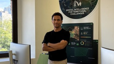
Thanks to a contract with the Lanzarote Society for External Promotion (SPEL), there is a company that collects and analyzes data from Lanzarote with the Sentinel 2 satellites of the Copernicus Programme of the European Space Agency on biodiversity, air quality, water, vegetation health, and tourism pressure.
This way, very valuable environmental information is obtained in the form of indicators for different areas of the island, with recommendations, for public decision-making. The intelligence company is called Murmuration and its main headquarters are in Paris, although it also has two other teams in Malta and Spain.
"To help manage a territory sustainably"
From Barcelona, Nicolas Renia, the company's representative for our country, speaks in an interview with Ekonomus. “Our objective is to help manage a territory efficiently and sustainably,” shares Renia, who holds a degree in Business Administration and Management.
The company is made up of a “team of 20 people, most of them data or environmental engineers”.
“We use the data collected by the satellites' sensors and radars to directly measure air quality and the state of vegetation in Lanzarote,” explains the Country Manager of Murmuration in Spain.
For other matters, more data needs to be cross-referenced. To know the state of biodiversity on the island, Murmuration uses the United Nations Mean Species Abundance (MSA) indicator.
Thus, they analyze vegetation images over time in different areas of the island, combined with the human impact on land use, to estimate how many native species remain.
To measure Lanzarote's water stress, the French company monitors parameters such as “soil moisture or precipitation levels” in each area of the island. It then cross-references the data with the citizen, agricultural, and tourist demand of the territory to detect water stress in real time.
How is tourism pressure measured?
“In tourism, we measure the number of buildings and homes that can accommodate tourists and combine it with the tourism information of the territory to calculate the threshold that must be respected for an ideal experience,” shares Renia.
“We analyze tourism pressure by considering international studies on tourism perception, combined with the supply capacity of tourism and accommodation in the area and comparing it with the population living there.”
“The idea is that with the data compared between several areas of the territory, tourist flows can be balanced”. Thus, it would be possible, for example, to decide to promote less saturated areas over others with more tourist pressure.
Add La Voz de Lanzarote as a preferred Google source.
Stay informed with the latest current news.