The Lanzarote Security and Emergency Consortium hosted this Wednesday a coordination meeting to analyze the situation of storm Therese. Thus, it has established the activation in pre-emergency mode of the Lanzarote Insular Emergency Plan, known as PEIN, from this Wednesday and they will meet again on Friday to analyze the situation.
At the meeting was present the president of the Lanzarote Security and Emergencies Consortium, Francisco J. Aparicio, accompanied by the manager of the security body, Enrique Espinosa. In addition, the city councils were also represented, as well as the councilors of Public Works and Water, Jacobo Medina and Domingo Cejas; the island director of the State Administration, Pedro Viera; and the island director of Education, Carmen Pellón; in addition to representation from the local police and the Civil Guard.
The president of the Cabildo, Oswaldo Betancort, has thanked the municipalities for their involvement when deploying coordinated preventive measures through the Consortium, from where a permanent update of the evolution of Therese is carried out.
“With this, there are already 19 storms this long winter, but we must maintain prevention for everyone's safety,” commented Betancort, who also emphasized the importance of heeding the recommendations of the Security Consortium. The president has emphasized warning about the large high tides expected for this week, adverse maritime conditions that will close part of the coast. Finally, he has invited the population to stay informed through official channels and follow the instructions of the security and emergency forces in Lanzarote and La Graciosa.
The president of the Lanzarote Security and Emergency Consortium, has also thanked “the coordination among everyone to work together for prevention.” “We are clear that the only way to work for this type of emergency is in a united way, as we have shown is the most effective,” he added.
Suspended the day of Grandparents Conejeros
As preventive measures, the Security and Emergencies Consortium recommends the suspension of outdoor extracurricular activities from this Wednesday. In this regard, it should be noted that the Physical Activity and Sports Area suspended the day of the Abuelos Conejeros tournament this Wednesday.
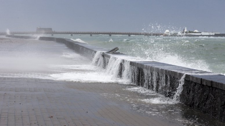
As was explained at the meeting, the high tides could be very high, also combined with adverse coastal phenomena. The wind will start this Wednesday with possible gusts of up to 70 kilometers per hour, being able to increase in different parts of the island.
Division of the emergency into two phases
For this reason, the Lanzarote Security and Emergencies Consortium will divide the situation into two phases. The first starts this very Wednesday with the PEIN in pre-emergency phase from today until Friday, since on Friday at 13:00 hours the situation will be analyzed again for the weekend
The Consortium, additionally, will raise the red flag in the west zone, and in the east zone civil protection and lifeguards are urged to be attentive to the intense high tides that may occur.
Regarding the rain, rain is expected from this Wednesday and it is expected to be with greater intensity in the early hours of Friday and Saturday morning. In this regard, the Consortium makes itself available to the island's town councils for the distribution of sacks. Likewise, citizens who wish to do so can go to the company Industrial Canarios de Forjados and there they will be given the sacks they need.
Protection measures in the face of the swell alert
- Protect your home from the possible invasion of seawater.
- Do not stand at the end of piers or breakwaters, nor risk taking photographs or videos near where the waves break.
- Avoid fishing in risk areas.
- Do not drive vehicles on roads near the beach line.
- Never swim on secluded beaches or those you do not know sufficiently, because there may be local whirlpools.
- Avoid swimming on beaches with a red flag, in areas with strong waves and rip currents, or that lack surveillance and rescue services.
- Avoid engaging in sports and nautical activities in areas affected by swell and do not camp on the beach when there is a sea storm alert.
- If you notice certain unusual waves, do not stay near the sea, nor approach, even if it suddenly calms down.
- If you have a boat, try to secure its mooring in a sheltered place.
- If you see other people in dangerous places, warn them of the danger.
- If you fall into the water, move away from where the waves break, call for help, and wait to be rescued.
- If you try to get out and are dragged by the waves, try to calm down; do not swim against the current and let yourself be carried. Generally, coastal currents lose intensity in other sections, and that is when you should swim.
- If you are on land and see that someone has fallen into the water, throw them a rope with a float, or any other object they can hold onto. Immediately call 1-1-2.
- For any information request, call telephone 0-12.
Protection against the yellow warning for rains
- Pay attention to weather forecasts and to the recommendations of the authorities regarding them.
- Check the condition of roofs, rooftops, and water drums, as well as drains and downspouts.
- Even if the sky is clear, do not park your vehicle in the bed of ravines.
- Check and have ready flashlights or candles, a camping-gas type stove in anticipation of a power outage, drinking water, medicines, a battery-powered radio, etc.
- Close and secure windows and doors to prevent water entry. Small protections can help protect you in case of flooding.
- Avoid hiking, going on excursions or camping until normality is restored.
- Avoid cycling or handbiking on island roads.
- Avoid road travel; if you have to do so, take extreme precautions and do not cross areas that may flood.
HOW TO ACT:
- Tune into the local radio stations and follow the instructions given.
- If you observe that the storm is accompanied by lightning or flashes, close windows and doors of the dwelling as air currents attract lightning.
- Unplug electrical appliances to prevent them from being damaged by a power surge or causing electrical discharges.
- In case of flood, disconnect the main electricity switch of the dwelling.
- If the storm surprises you while driving, reduce speed and take extreme precautions as the roadway may be affected by landslides.
- Do not stop in areas where a large amount of water may flow, nor cross flooded sections to prevent the force of the water from dragging you away.
- Stay away from towers, fences or any other metallic structure.
- Do not take shelter under trees. Remember that wet wood is also a conductor of electricity.
- In the city, buildings can protect you from the risk of discharges.
- In the countryside, look for low areas avoiding deep valleys; the slopes of the mountains are safer.
- Avoid calling by phone, in order to prevent the lines from collapsing.
Prevention for wind warnings
- Close doors and windows to avoid drafts that can lead to the breakage and fall of glass.
- Remove from balconies and rooftops flowerpots and all objects that could fall onto the street.
- Check homes so that there are no cornices, balconies, and facades in poor condition that could cause falling debris and rubble.
- Avoid going on excursions or camping until normality is reestablished.
- Try to postpone road trips and if you do, take extreme precautions. The use of public transport is recommended.
- Motorcycles and large vehicles that offer a large contact surface with the wind (trucks, vans, vehicles with trailers or caravans) run the risk of overturning in crosswinds.
HOW TO ACT:
- Avoid walking through gardens or wooded areas.
- Stay away from walls, old houses, scaffolding, illuminated signs, billboards and other structures that may be knocked down by the wind.
- Light poles and tension towers are dangerous. Stay away and in case of risk, call 1-1-2.
- In case of risk from construction cranes, immediately call 1-1-2.
- Try to stay away from the coast (beaches, promenades, pier breakwaters, etc.) to avoid being hit or dragged by the action of the waves.
- Drive slowly and with caution due to the possible presence of obstacles on the road or gusts of wind that may cause you to lose control of your vehicle, especially when overtaking.
- Avoid calling by phone, in order to prevent lines from collapsing.
Recommendations in the face of the risk of floods
- Provide for the signage of the areas that habitually suffer damage in the municipality (premises, ground floors, car parks, promenades, etc.).
- Monitor areas of possible landslides.
- Inform and put on alert the municipal officials and the members of the municipal organization.
- Be attentive to the weather information and, especially, to the warnings issued from CECOES 1-1-2.
- Establish the mechanisms of surveillance and information about the situation.
Determine points of surveillance
- Mark or buoy the flood-prone areas of the municipality: avoid vehicle parking there, ensure that no activities that could be affected are carried out.
- Make a forecast of available and necessary resources.
- Establish the corresponding notices to emergency services, basic services, and entities.
- Control access to promenades, breakwaters, and dikes.
- Evacuate beaches if appropriate and prevent swimming in the sea and prohibit sports and recreational activities in the sea.
- In a situation of imminent risk, cut off traffic on those roads or paths that lead to flood-prone areas (traffic control). Especially mark and cut off fords.
- Notify the population in areas where the evolution of the situation makes damage foreseeable.
- Evaluate the constitution of the CECOPAL and the management and advisory bodies of the PEMU.
- Regarding municipalities, the following actions are recommended for risk of rain/floods.
- Keep sewers, storm drains, sumps, possible water passages, among others, clean, in order to facilitate water drainage.
- Remove leaf litter, accumulation of soil and/or other types of material that could clog and block sewers, channels, etc. And check these drainage points whenever rain warnings occur or after heavy showers.
- Foresee the signaling of flood-prone areas of the municipality (vehicle parking lots, camping areas).
- Control areas of possible landslides.
- Inform and alert municipal officials and members of the municipal organization.
- Be attentive to meteorological information and, especially, to warnings issued by CECOES 1-1-2. Establish surveillance and information mechanisms on the situation.
Determine Surveillance Points with the following functions
a) Mark or buoy the floodable areas of the municipality: avoid in the parking of vehicles, watch that there are no campers, ensure that activities that may be affected are not carried out.
b) Especially monitor ravine areas which often lead to rapid and dangerous floods.
c) Cut off traffic on those roads or paths that lead to flood-prone areas (traffic control). Especially signpost and cut off fords.
d) Notify the population that is in the areas where the evolution of the situation makes it foreseeable that the flood will occur. Make a forecast of available and necessary resources.
Add La Voz de Lanzarote as a preferred Google source.
Stay informed with the latest current news.